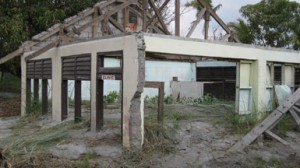
In June of 1991, Mt. Pinatubo on the Philippine island of Luzon blew its stack, sending up a giant plume of ash 25 miles high. Most of the destruction in human terms, however, came with a typhoon, in which a deadly mixture of water and ash caused massive lahars to wash over a huge amount of land, displacing over 100,000 people, and killing over 1,000. For the most part, the land taken by the lahars has never been recovered.
You can take a 4 wheel tour to Pinatubo’s crater, but it will cost you a minimum of 3,500 pesos ($77 USD) to share a vehicle. If you want to get closer to the lahars on an easier ride, you can rent a car, drive north of Olangapo near Subic Bay, and check out the Lahar Watchpoint, 12 km north of Cabangan on the National Road. Here, a recent bridge fords the lahar. Driving several kilometers north, you’ll begin to see buildings partially or totally buried by the lahar. Among the most interesting series of destroyed structures is the Carael Elementary school, where the ash encroached on classrooms and school buildings, undermined foundations, and destroyed adjacent houses, rendering it all useless. Everything has been left pretty much as it was when the lahar hit, leaving a ghost town humbling in its deference to nature.

Leave a Reply