Beginning just 50 km east of Taipei is what we here at WoWasis believe to be one of the most scenic drive in Taiwan, the Northeast National Scenic Area route, along Provincial Highway 2. Here, you’ll see marvelous sea views, wonderful geological formations, and several lighthouses. It starts at Nanya, and runs 66 km south to Toucheng. If you choose to proceed south from there, you’ll see the Yilan coast as well, on your way to Taroko Gorge. Continuing south from Taroko, you’ll drive along the East Coast National Scenic Area.
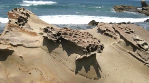
Your first highlight is the Nanya Rocks, where brilliantly weathered rocks stand in a lovely seascape. . Nanya’s parking lot (the sign reads ‘Nanya Particular Stone’) is located on the western side of the road between the 81 and 82 km markers at GPS: N25°07.150’ E121°53.569’.
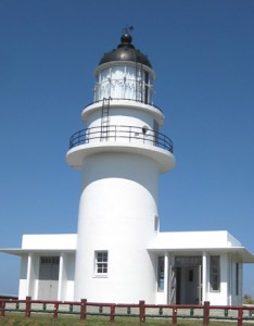
Bitou Cape is located 1.6 km south. Drive up to the Bitou Elementary School parking lot and take the trail to the 40 foot high Bitou Lighthouse, and be sure to notice the rocks weathered into patterns by the sea below you.
Into rock climbing? Longdon Cape (km 87) has 30 meter (110 foot) sandstone cliffs, and instruction is available.
Just south of the 100k Marker is the Fulong Visitors Center, where English-speaking rangers give out a very good English map of the scenic area.
Santiao Cape, just south of km 108, is the easternmost part of Taiwan, and here the Santiao Chiao (San Diego Cape) lighthouse has gorgeous views, and a small exhibit area within the lighthouse itself (closed Mondays).
At the 117 km marker, you’ll find the town of Dali, home to the Dali Tiangong Temple, affording a beautiful view over the ocean. Dali is also the southern terminus to the Caoling Historic Trail, an 8km foot trail with nice ocean views and historical buildings and temples, which runs north-south, and bisects the cape.
The scenic area officially ends near the 135 km marker. On the drive, you’ll pass many seafood restaurants and fishing towns, and great views. While you’ll see wonderful scenery, it won’t include many westerners, and English isn’t spoken much here (most people touring this area are Taiwanese, Chinese, or Japanese). Sign language does wonderfully, though, as friendly Taiwanese residents are always happy to guide you to an eating or sleeping establishment. The map you’ll receive at the Fulong Vistors Center (above) is important, as it’s bilingual, helpful for when you’re looking for something, as you can point to the Chinese script which accompanies the place you’re seeking.
This lovely drive is easily made from Taipei. If you don’t wish to continue south to Taroko Gorge, you can take Regional highway 2 at the 139 km marker, which links to highway 5, back to the Taipei area.


Leave a Reply